Recent searches
Search options

#lawx
1 post1 participant0 posts today


#NWS #flood #nwsflashflood #FlashFloodWarning Flash Flood Warning for Iberville, LA; West Baton Rouge, LA #LAwx https://alerts-v2.weather.gov/search?id=urn:oid:2.49.0.1.840.0.54dbd0b9496ec27cc7af8f0c94ca1d2edbb7a84f.001.1


Hmm, that's a lot of rain for just a thunderstorm (over New Orleans)... 5-7 inches, more falling. 
The National Weather Service in New Orleans has extended the
* Flash Flood Warning for...
Northeastern Jefferson Parish in southeastern Louisiana...
Southwestern Orleans Parish in southeastern Louisiana...
Western St. Bernard Parish in southeastern Louisiana...
* Until 645 PM CDT.
* At 543 PM CDT, Doppler radar indicated thunderstorms producing
heavy rain across the warned area. Between 5 and 7 inches of rain
have fallen. Flash flooding is ongoing or expected to begin
shortly.
#NWS #flood #nwsflashflood #FlashFloodWarning Flash Flood Warning for Jefferson, LA; Orleans, LA; St. Bernard, LA #LAwx https://alerts-v2.weather.gov/search?id=urn:oid:2.49.0.1.840.0.57fbb4cb4944ad6f5349a4e61618eabae2fdc6a5.001.1


#NWS #flood #nwsflashflood #FlashFloodWarning Flash Flood Warning for Jefferson, LA; Orleans, LA; St. Bernard, LA #LAwx https://alerts-v2.weather.gov/search?id=urn:oid:2.49.0.1.840.0.ed99bda7d42b77e55506ee8aeb89d5eb3bcfe5d3.001.1

Hmm, the big green areas towards the middle are the Mississippi River, which is apparently flooding. #flooding #LAwx #ARwx #MSwx https://nowcoast.noaa.gov/


#EAS #WEA for Columbia, #AR; #Lafayette, #AR; #Miller, #AR; #Nevada, #AR; #Bossier, #LA; #Caddo, #LA: #Tornado Warning issued April 2 at 6:53PM CDT until April 2 at 7:45PM CDT by NWS Shreveport LA Source: NWS Shreveport LA #Columbia, #AR; #Lafayette, #AR; #Miller, #AR; #Nevada, #AR; #Bossier, #LA; #Caddo, #LAwx** DO NOT RELY ON THIS FEED FOR LIFE SAFETY, SEEK OUT OFFICIAL SOURCES ***
#EAS #WEA for Columbia, #AR; #Claiborne, #LA; #Webster, #LA: #Tornado Warning issued April 2 at 5:55PM CDT until April 2 at 6:30PM CDT by NWS Shreveport LA Source: NWS Shreveport LA #Columbia, #AR; #Claiborne, #LA; #Webster, #LAwx** DO NOT RELY ON THIS FEED FOR LIFE SAFETY, SEEK OUT OFFICIAL SOURCES ***
#EAS #WEA for Columbia, #AR; #Claiborne, #LA; #Webster, #LA: National Weather Service: #TORNADO WARNING in this area until 6:30 PM CDT. Take shelter now in a basement or an interior room on the lowest floor of a sturdy building. If you are outdoors, in a mobile home, or in a vehicle, move to the closest substantial shelter and protect yourself from flying debris. Check media. Source: NWS Shreveport LA #Columbia, #AR; #Claiborne, #LA; #Webster, #LAwx** DO NOT RELY ON THIS FEED FOR LIFE SAFETY, S


#EAS #WEA for Bossier, #LA; #Claiborne, #LA; #Webster, #LA: #Tornado Warning issued April 2 at 5:19PM CDT until April 2 at 6:00PM CDT by NWS Shreveport LA Source: NWS Shreveport LA #Bossier, #LA; #Claiborne, #LA; #Webster, #LAwx** DO NOT RELY ON THIS FEED FOR LIFE SAFETY, SEEK OUT OFFICIAL SOURCES ***
#EAS #WEA for Bossier, #LA; #Claiborne, #LA; #Webster, #LA: National Weather Service: #TORNADO WARNING in this area until 6:00 PM CDT. Take shelter now in a basement or an interior room on the lowest floor of a sturdy building. If you are outdoors, in a mobile home, or in a vehicle, move to the closest substantial shelter and protect yourself from flying debris. Check media. Source: NWS Shreveport LA #Bossier, #LA; #Claiborne, #LA; #Webster, #LAwx** DO NOT RELY ON THIS FEED FOR LIFE SAFETY, SEE

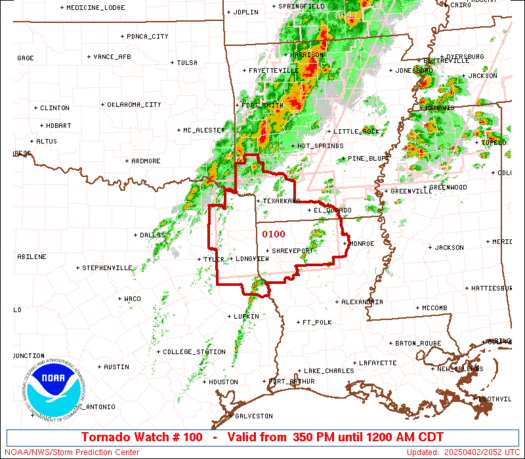
TORNADO WATCH #100 Issued for Southern Arkansas, Northern Louisiana, and Northeast Texas
Primary threats include a few tornadoes (couple possibly intense), scattered damaging winds to 70 mph, and hail up to 2 inches possible.
Multiple zones of severe storms expected through late afternoon and early evening across the ArkLaTex region. Be prepared to take shelter if warnings are issued.
Continued thread


Continued thread


#EAS #WEA for Livingston, #LA; #St. John The Baptist, #LA; #Tangipahoa, #LA: National Weather Service: #TORNADO WARNING in this area until 7:45 AM CDT. Take shelter now in a basement or an interior room on the lowest floor of a sturdy building. If you are outdoors, in a mobile home, or in a vehicle, move to the closest substantial shelter and protect yourself from flying debris. Check media. Source: NWS New Orleans LA #Livingston, #LA; #St. John The Baptist, #LA; #Tangipahoa, #LAwx** DO NOT REL
#EAS #WEA for Livingston, #LA; #St. John The Baptist, #LA; #Tangipahoa, #LA: #Tornado Warning issued March 31 at 7:03AM CDT until March 31 at 7:45AM CDT by NWS New Orleans LA Source: NWS New Orleans LA #Livingston, #LA; #St. John The Baptist, #LA; #Tangipahoa, #LAwx** DO NOT RELY ON THIS FEED FOR LIFE SAFETY, SEEK OUT OFFICIAL SOURCES ***